The Apprehensions of the Past in Building the Future: Do the Master Plans for Damour and Dibbiyeh Encourage Return?

Last year, a broad debate surrounded director Ziad Doueiri’s film The Insult, especially after it was nominated for the 2018 Oscar for best foreign language film. This was the first time that a Lebanese film has been shortlisted for an Oscar.
During the film’s first few minutes, one of the main characters expresses her wish to return to Damour, stating that the church there had been restored. Her husband, a survivor of the massacre that occurred in the town during Lebanon’s Civil War, firmly rejects the idea. Doueiri then leads the audience away from the subject of Damour to insert them into the story of case no. 23, from which the film derives its Arabic title. The case eventually brings the audience back to the basis on which the film began: the aforementioned Damour Massacre.
Many felt that the film’s contention is segregationist, manipulates the massacres, and isolates painful historical events from one another.[1] Yet the special screening of the film held in Empire The Spot Choueifat Cinema and attended by the people of Damour paints a more complex picture. According to press coverage, the people of the town were greatly affected by the film and gave it a communal applause. Charles Ghafari, Damour’s mayor, declared that “The film means a lot to the people of Damour … It gives Damour its due”. As for Doueiri, he said, “This meeting with the people of Damour is very important to me and the actors, for the story is ultimately the story of these people and this small town”.
In fact, both perspectives take great leaps, for in the film, Damour appears only via the massacre and is stripped of any context. The same cannot be said about Lebanese producer Reine Mitri’s film In This Land Lay Graves of Mine. Unlike Doueiri’s film, Mitri’s film – which the minister of interior banned from screening in Lebanon[2] – works to close the gap between the tragedies of the Civil War, on one hand, and the authorities’ (both local and national) handling of them after the war. Like many other people, Mitri sells her summer house located in one of the Christian villages to a Muslim buyer. In her film, she speaks to Lebanese who experienced the Civil War and its horrors. They relate their stories about the ongoing land purchases and fear of the other. These interviews are spliced with revealing archival material and images of the urban transformations that the villages and towns on the coast of Chouf and Iqlim al-Kharroub are undergoing.
In this article, by focusing on the towns of Damour and Dibbiyeh, we will explore the topic of displacement, return, and fear in the context of the urban developments that these villages have undergone since the 1990s and the general master plans that have contributed to the lack of return to them.
When the Lebanese Civil War began, the Chouf coastal areas witnessed demographic changes and a sudden displacement of their residents, particularly the Christians. This displacement occurred in two waves, the first in 1975 and 1976 after the Damour Massacre and the second in 1984-1985 during the so-called Mountain War.[3]
After the war ended and the reconstruction of Beirut began, the rise of real estate prices there led waves of the most vulnerable inhabitants to settle in Iqlim al-Kharroub, taking advantage of its proximity to the city and the real estate projects underway in the early 1990s and the second half of the 2000s.[4]
This process of rapid urbanization occurred in the absence of equitable development policies and in isolation from the local context. The construction and property development sector contributed little to the local development of the towns on the coast of Chouf and Iqlim al-Kharroub. To the contrary, it put additional pressure on resources, which fueled sectarian and political tensions. Property developers from outside the region seized the opportunity presented by relatively affordable lands available on the coast of Iqlim al-Kharroub and Chouf.
Most of the newcomers buying homes in the region are Sunni or Shia, while a large portion of the land being sold belongs to Christians who have had no motivation to return to the region.
Although these rapid changes to the rural environment are caused by market forces, they have fueled sectarian fears about a change in the region’s social identity and fabric, fears sown and consolidated by the history of sectarian violence and massacres.
How have Damour and Dibbiyeh’s local authorities handled this historical situation, and how have they directed land planning?

Damour, Who Are You?[5]
We now wander among the berry trees on the Damour plain … the gentle spring of the Damour coast … Marvelous are these houses scattered in every clearing among the berries, cane houses raised on wooden stilts (which they call khisas) inside which we can explore an amazing secret of nature … When the picking season approaches, workers come from the neighboring villages to help the Damourians pick the [silk] cocoons … Nobody in Damour asks a worker about his identity.
With these words, author Michel Ghorayeb describes his town Damour in his book Damour, Who Are You? The coastal village was ranked first among the villages producing silk cocoons in Lebanon at the beginning of the 20th century. In 1905, Damour had five silk factories.[6] During the French mandate, the silk season in Damour witnessed an unusual recession and an increase in taxes, which caused a major crisis. Many silk cocoon merchants and factory owners in Damour went bankrupt.[7] Within a few years, the Damour plain had turned to banana and lemon cultivation, which led to a change in customs and lifestyles. Damour recovered from the silk disaster, the houses and shops multiplied, and by 1975 the population had reached approximately 20,000. During the 1970s, the population growth, the proximity to the capital, and the convenience of transport to it led Damour to become akin to a rural suburb of Greater Beirut.
Damour’s first general master plan was produced in 1968. It embodied the town’s situation at that time with regard to the dominant forces, priorities, and orientations. The plan divided the municipality into six areas: two mixed areas for commerce and housing, a residential area, an agricultural plain, an industrial area, and a tourist area. The old town was assigned the highest ground exploitation ratios to encourage construction therein and limit the urbanization of agricultural lands and natural areas. An area parallel to the agricultural plain and extending along the coast was allocated to tourism and luxury private houses. Thus, although Damour was still a distinctly agricultural village, the general master plan launched a vision for attracting tourist activities to the beach and erecting villas for wealthy families. Note that President Camille Chamoun built himself a palace on the Saadiyat coast in southern Damour.
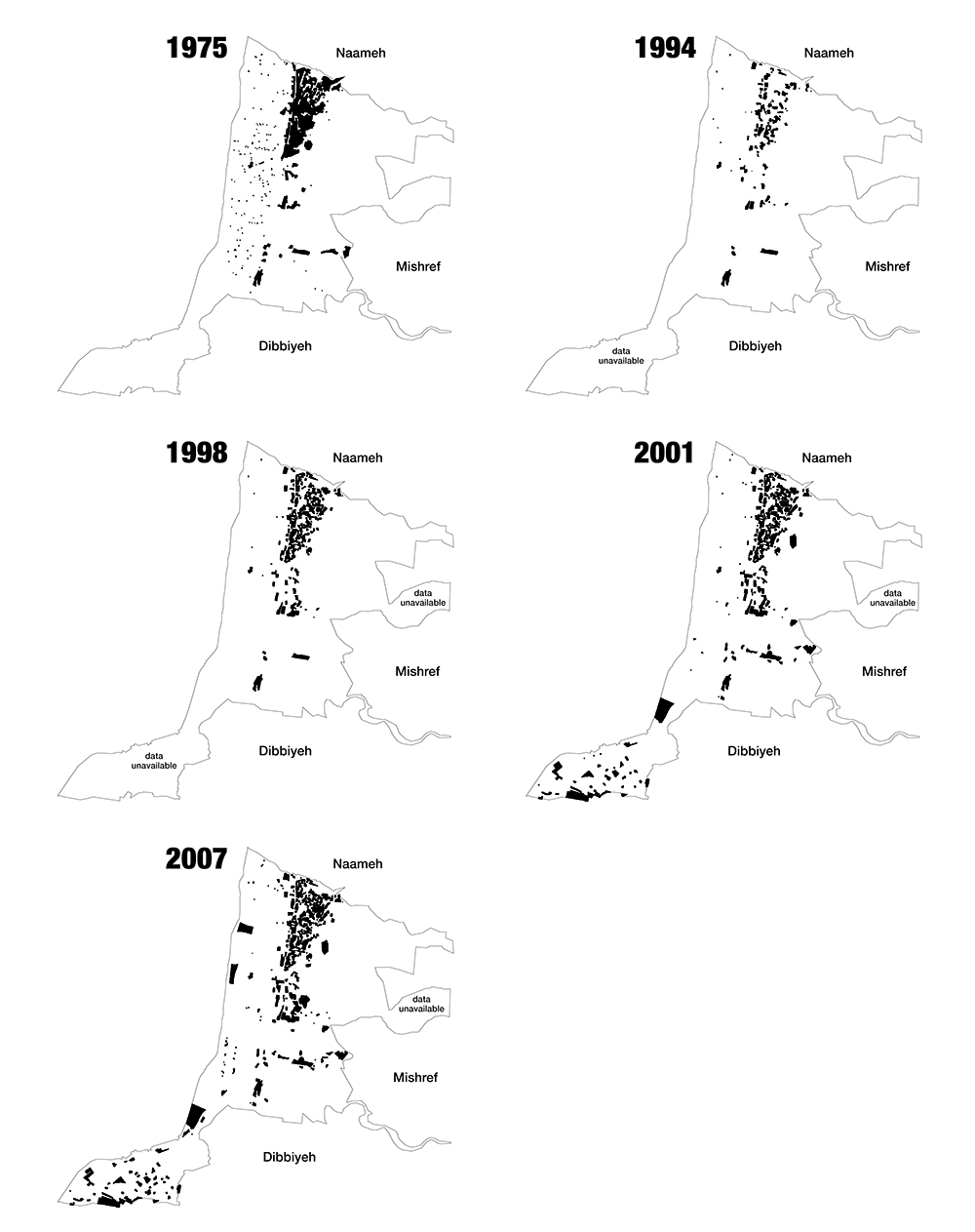
With the beginning of the Civil War and after a painful massacre, Damour witnessed rapid changes and a sudden displacement of its residents. Approximately 620 buildings were destroyed, the agricultural plain was deserted, and the Damour shoreline suffered sand dredging that narrowed it by 25 meters.[8]

The war dramatically changed the region’s demographics, and only a small percentage of the Christian residents, who had adapted to life in other parts of Lebanon, returned to their homes when it ended. During the reconstruction phase, Damour was subject to a specific plan for the return of the displaced, and in 1994, Law no. 322 was issued, permitting them to build on properties not meeting the legal conditions for construction. In 1996, 662 buildings were counted in Damour, and the permanent residents were estimated to number 1,000.[9] Two years later, 752 buildings were counted via aerial photos, which amounts to a 13.5% increase. Nevertheless, the rate of return remained low and limited either to the reconstruction of some houses in the old town by its people or to major private projects on Damour’s hills in the form of gated communities, particularly the Mishref project, which launched in 1994.
In his book, Ghorayeb also describes “New Damour, a dream in the minds of the town’s sons and daughters”. The displaced waver between a rosy image of a vibrant past and the tragic image of destruction. The two alternate, but they are counterpoised with a third image, one of Damour today, a figment of their imagination because “The return of the displaced to their homes … produced only a few scattered houses”.[10]
Today, approximately 30,000 people are officially registered in Damour, while the resident families number 5,000.[11] There appears to be a sharp divide between the Christian Damour and the Sunni Muslim Saadiyat, which falls within the Damour municipal limits, amidst demands by the latter’s population (who are known as the “Saadiyat Arabs” and were there before the Civil War) to break away from Damour.[12]
In parallel, people from various social groups (most of them Muslims) have moved to Damour and the surrounding villages to escape the rise of housing prices in Beirut. Under these circumstances, the sectarian social tension and fear-mongering have worsened. What have the local authorities done to deal with the apprehensions of the past and the demands of the present?
A Classist Vision and Economic Interests Under a Sectarian Cover
In 2008, forty years after the first general master plan, a new plan was issued for the Damour region. A municipal council member explains,
We created the new plan as it serves the interest of Damour and its people in reducing exploitation and increasing the area of residential apartments to concord with our vision for the town. The old plan included an industrial area, which was abolished. We also created an area classified for tourism along the shoreline, where the tourist resorts are currently located. The Damour municipality thus came to be based on a touristic-environmental master regulation.

Looking at the new general master plan’s map and the chart of changes that accompanies the plan, we find exploitation ratios that are generally lower than the previous ones, which is remarkable in view of the surrounding towns and the towns along the Lebanese coast in general. When we asked the municipality member why, he said,
We want Damour to be tidy and attract outsiders. Imagine if we allowed the construction of buildings with two, three, or four apartments on the one level – the area would become sha’biyya [i.e., a poorer or working-class area], and that’s not our vision. In the general master plan, we reduced exploitation for this reason. We made the areas of properties larger and the apartments large, up to 200 square meters. We added stone and tile to the [materials used in] facades. As you know, Damour was destroyed and its people displaced; with the return, there was haphazard construction and contiguity… but we solved the issue in the new plan.
These words make the municipality’s vision for Damour’s future clear: it is one based on a classist foundation and economic interests. The undesirable residents are those who cannot afford to buy a house or live in the “new” Damour, especially as most of the inhabitants moving to Damour are Muslims displaced from Beirut by the rising costs of living there.
In an interview we conducted with a construction contractor working in Dibbiyeh and Damour, he said,
The [Muslim] contractors are building in Iqlim [al-Kharroub] and on the Chouf coast, and they bring their acquaintances to live there. But as for Damour, we call it ‘the Damour desert’, because they [i.e., the local authorities] refuse to register works and construction to non-Christians in order to bar them from the construction business… with the exception of Saadiyat [which is located in southern Damour and has a Muslim majority].
In conjunction with this “constriction” imposed on construction under the banner of preserving Christians’ property, there are also the beach resorts (which today number 17 on the Damour coast) and the exclusive residential complexes that the new general master plan encourages erecting. The map of land ownership shows that a high percentage of the properties containing the resorts and luxury residences belong to investors or real estate companies, in contradiction with the rhetoric about preserving Damour for its people. There is also the issue of the Mtill real estate project, which several press articles considered to be the direct impetus for issuing the general master plan in 2008.
Via a political partnership between Mayor Ghafari and MP Elie Aoun (a member of MP Walid Jumblatt’s bloc), the Investment and Property Development Company, owned by Auon and the Saudi Tariq al-Rasan, was able to acquire lands in Damour and begin constructing a group of massive residential projects encompassing many buildings under the name “the Mtill Project”.[13] The classification of these lands had not permitted construction, but the 2008 plan reclassified the properties of the project to “2MA”, a classification for private housing. The project caused anger among Damour’s people, who wondered why their lands were being sold and why projects that they would not live in were being erected upon these lands. In response, the owners of the Mtill project decided to grant Damour “natives” a 30% discount on apartment purchases in the project. The municipality issued a similar decision concerning the beach resorts, allowing Damour “natives” to enter some of them free of charge on certain days of the week.
Discussion about the Mtill project continued until the 2016 municipal elections, whose main slogans were “Damour’s land is not for sale”, “Damour for the Damourians”, and “the Damour plain is not for sale”. Mayor Ghafari’s opponents stressed that as the project contained 300 residential apartments, it would disrupt the demographic balance between Christians and Muslims in Damour. Ghafari responded that “This project consists of 50 luxury villas that fall within the scope of the Mishref project. Hence, it cannot affect the region’s demographics given its very high cost”.[14]
Maintaining indigenous land ownership has become a theme of electoral battles and inflammatory discourses, but the core of the issue lies in economic interests and the classist vision of Damour’s future that excludes whoever cannot afford it. Protecting and strengthening local resources is essential in any urban planning process, and it cannot be reduced to limiting exploitation ratios on classist and sectarian bases. Today, open green spaces constitute 55% of Damour’s land, but in light of the current general master plan, they constitute an embodiment of the prevailing ownership relations and a replication of inequalities.
Equitable development would have been possible had a general master plan that addresses the apprehensions of the past and involves the the populace (both original and resident) and their needs and priorities been developed. Had that occurred, it might have created a true path for those who were displaced and want to return to do so.
Planning Dibbiyeh: Between Private Interests and Public Apprehensions
Dibbiyeh is located 30 kilometers south of Beirut and is the coastal gateway to Iqlim al-Kharroub in Chouf. It consists of the old village, located at the heights of the towns, and a number of surrounding green hills and highlands overlooking the sea, which have been built upon and exploited haphazardly since the 1990s. The establishment of the Beirut Arab University’s campus and a branch of the Lebanese University played a key role in boosting Dibbiyeh’s economy and in its urban expansion. Despite this moderate growth, the township retained its distinctive green spaces through the years – until the construction of a gated housing project spanning more than 2000 square kilometers on its western hills began in 2017.
1998: The First Attempt to Urbanize Dibbiyeh’s Western Hills
The first master plan issued for the Dibbiyeh region was ratified by Decree no. 11855 of 1998. According to lawyer Shadi Salim al-Bustani, it “regulated urbanization, construction conditions, subdivision and land pooling, the surface and general exploitation ratios, and zoning after a specialized engineering study by the municipality that preserved the existing rural, environmental, traditional, and physical character and the town’s identity and history”.[15]
However, according to architectural engineer and developer Jalal al-Ali,[16] the enormous number of subdivision areas in the town’s first plan suggests an intent to attract residents to Dibbiyeh and boost its economy during that period. He also explains that “There is a propensity to sell and greater openness in areas like Dibbiyeh and Jiyeh, where the population is more diverse than in Damour and where we find a large portion of the Christians that were displaced in the early 1980s and have not yet returned. This group also doesn’t hesitate to sell their property and migrate”. Because Dibbiyeh overlooks the sea, the lower section constituted a desirable location for property development, in clear contradiction with the town’s character. However, despite the subdivision of these vast areas, Dibbiyeh did not experience the level of demand to which it aspired, so the greater portion of it remains undeveloped.
Fears, Politics, and Manipulations: The Purchase of Tel Dalhamiyya
At the beginning of this century, the town witnessed a wave of land purchases by “outsiders”,[17] as confirmed by al-Ali: “Since the 1990s, everyone has bought on Dibbiyeh’s coast. There are politicians with land, and the Shia expatriates living in Africa have also made purchases”.
During that period, the al-Bustani family offered a part of its land known as “Tel Dalhamiyya” for sale. The land – a green hill overlooking the sea – spans approximately 3,500 square kilometers.[18] A part of it (approximate 1,000 square kilometers) that includes the golf club had been classified a “protection area” in Dibbiyeh’s first general master plan in 1998, meaning that construction therein was very restricted.
Ali Taj al-Din, a Shia merchant said to be close to Hezbollah, became interested in buying the land. According to journalist Pierre Atallah, when the residents of Dibbiyeh learned of the potential purchase, they turned to one of the authorities in the Maronite Church in an attempt to block it. Subsequently, wealthy Maronite businessman Robert Mouawad, rather than Taj al-Din, bought the land to develop a tourism project within the existing construction conditions. However, Bahij Abou Hamze, who was then an advisor to Walid Jumblatt, intervened in the project, which led to Mouawad relinquishing his shares in the Dalhamiyya Development Company to Taj al-Din in 2011.[19] Through this process, actual ownership of the land transferred without the municipality’s knowledge, for it occurred via the Commercial Register[20] without the transfer of landownership being registered.[21]
This deal provoked several reactions in the media, most of which employed sectarian rhetoric that reflected and amplified the existing fears in the Dibbiyeh township and surrounding area, especially about demographic change and scheming by political parties. The transfer of Dalhamiyya was linked to similar real estate transactions occurring on a broader scale in the region.
For-Profit Planning: The Dalhamiyya Development Company Reshapes Dibbiyeh
In 2012, the Dibbiyeh municipal council met to vote on amending the 1998 general master plan to raise the exploitation ratio in the areas of Dalhamiyya and Halyuna. The meeting occurred at the request of the Dalhamiyya Development Company after Taj al-Din acquired it. However, the council rejected the amendment request via a six-to-five majority. Then, in 2012, a second meeting convened to reexamine the request. The council accepted it after one of the previous opponents was persuaded. Consequently, the council dissolved because half its members resigned. The resigning members, represented by lawyer Shadi Salim al-Bustani, filed a challenge to the municipal decision to amend the master plan before the State Shura Council (Challenge no. 18040 of 2012).
On this basis, during the electoral battle in the following weeks, the municipal council’s members divided into two competing lists. The pro-amendment list (“Dignity and Free Choice”) won, and on July 6, 2013, a municipal decision was issued requesting a raise in the exploitation ratio for the areas of Dalhamiyya and Halyuna. The Higher Council for Urban Planning then issued a decision approving an increase in the exploitation ratio, but because it applied throughout the Dibbiyeh region, the municipal council issued a decision to suspend it. Shadi Salim al-Bustani accused the amended plan of “passing shady deals and legitimizing grave violations of the current classification decree in order to secure private interests and benefits at the expense of the public interest of Dibbiyeh’s people”.[22]
In 2016, the new municipal council requested a six-month timeframe to prepare an objective study of the new plan resulting from the real estate company’s request.[23] This situation was exploited to kindle sectarian rhetoric, with no attention paid to the issue of public interest, the project’s environmental effect on the town and its limited infrastructure, the extent to which the existing general master plans are binding, and the reasons for amending them. In late 2016, the changing party alliances on the national level translated into the ratification of the new general and detailed master plan for Dibbiyeh via Decree no. 4548 of October 27, 2016, after current prime minister Saad Hariri nominated current president Michel Aoun for the presidential elections and before the transition to a caretaker government. Today, what remains of the Tel Dalhamiyya reserve is enclosed by the branded hoarding boards of the project Medyar: A City Rise.
This article is an edited translation from Arabic.
Arabic article available here.
This article was originally published in Arabic as part “Master planning in Lebanon: Manufacturing of Inequality” (July 2018). This publication is the outcome of a research project by Public Works Studio in collaboration with the Legal Agenda.
Related articles:
To Pit Agriculture Against Tourism: The Case of the Zahrani Coast
Planning Zouk Mikael: Ignoring the Power Plant of Death
The Legislative Framework for Urban Planning: No Voice for the People
Master-Planning in Lebanon: Manufacturing Landscapes of Inequality
[1] Hazem al-Amin, “al-Masihiyyin Ahabbu Film Ziad Doueiri”, Al-Hayat, October 15, 2017; Saleem Albeik, “Qadiyyat Raqm 23 aw Kayf Tukarrih bi-l-Falastiniyyin”, Alquds Alarabi, February 3, 2018.
[2] “Li Qubur fi Hadhihi al-Ard Mamnu’!”, almodononline, June 17, 2015.
[3] Butrus Labaki and Khalil Abu Rujayli, Jardat Hisab al-Hurub min Ajl al-Akharin ‘ala Lubnan, Beirut, 2005.
[4] UNDP, “An Urban Suburb with the Capacities of a Village: The Social Stability Context in the Coastal Chouf Area”, Beirut, 2017.
[5] Michel Ghorayeb, Damur Man Anti? Aw Ma’sat al-Damur, printed at the expense of Rose Ghorayeb, 2000.
[6] Figures sourced from the book Damur Man Anti? (op. cit) and Ibrahim al-Aswad, Dalil Lubnan, 2nd ed., Baabda, 1906.
[7] The mandate state did not intervene to protect national industry or establish a bank to lend to industrialists.
[8] UNEP, Mediterranean Action Plan, Ministry of Environment,
“Coastal Area Management Program”, July 2004.
[9] Lebanese Central Administration of Statistics.
[10] Michel Ghorayeb, Damur Man Anti?, op. cit.
[11] UNEP, “Coastal Area Management Program”, op. cit.
[12] UNDP, “An Urban Suburb with the Capacities of a Village”, op. cit.
[13] Firas Al Shoufi, “Solidere Saghira fi al-Damur”, Al-Akhbar, November 24, 2012.
[14] Ghafari is suggesting that Muslims moving to this region (the Chouf coast) to escape high housing prices in Beirut cannot afford to purchase property in this project.
[15] Shadi Salim al-Bustani, “La Asbab Muwajjiba li-Ta’dil Tasnif al-Dibbiyya”, Annahar, August 31, 2016 (goo.gl/A7eQV9).
[16] Jalal al-Ali has worked and lived in the area for 36 years. We interviewed him during field research.
[17] Pierre Atallah, “al-Dibbiyyeh Dahiyya li-l-Samasira wa-l-Tujjar”, Annahar, May 9, 2014.
[18] Ahmad Mansur, “al-Dibbiyyeh: ‘Bay’ al-Aradi wa-Ta’dil al-Mukhattat al-Tawjihiyy Mihwar Ma’rikat al-Baladiyya’”, Bawwabat al-Iqlim, March 3, 2013 (goo.gl/7abrt5).
[19] Viviane Akiki, “Mashru’ ‘al-Dalhamiyya’: Ijtrar Nazariyyat ‘al-Wujud al-Masihiyy al-Muhaddad”, Al-Akhbar, August 23, 2016 (http://www.al-akhbar.com/node/263548).
[20] “Baladiyyat al-Dibbiyyah Lam Tataballagh Bay’ Aradin fi Kharajiha”, Janoubia, December 27, 2011.
[21] Viviane Akiki, “Mashru’ ‘al-Dalhamiyya’”, op. cit.
[22] Shadi Salim al-Bustani, “La Asbab Muwajjiba li-Ta’dil Tasnif al-Dibbiyya”, op. cit.
[23] Ministry of Labor, “Iqtirah al-Wazir Qazzi fi Majlis al-Wuzara’ Hawl al-Tasmim al-Tawjihiyy li-Mintaqat al-Dibbiyya”, August 18, 2016 (goo.gl/irqeFx).