Falsifying Property Ownership in El Mina, Lebanon (Part I)

The case of the fake property in El Mina, North Governorate, Lebanon, is one of the best examples of encroachment on maritime public properties or, rather, their abandonment. The story of this property is not new: it began in the late 1960s, and several ministers of public works and transport have engaged in it. While some succeeded in protecting the public property, others, including current Minister of Public Works and Transport Youssef Fenianos, were derelict in their responsibilities in this regard.
Below, we shall recite the details of this case and then, on that basis, once again raise the following key questions: Who protects public property? What can citizens do if the state and the Ministry of Public Works forsake their role in protecting public property? Can citizens stand in lieu of the state and ministry to exercise their right and duty to protect what remains of the state? Does it not make sense for direct forms of democracy (including citizens taking it upon themselves to defend the state’s rights directly) to acquire renewed legitimacy given the collapse of the institutions of representative democracy and their failure to protect what was entrusted to them?
A Property that Writes the State’s History: How has the State Handled the Attempts to Privatize Public Property?
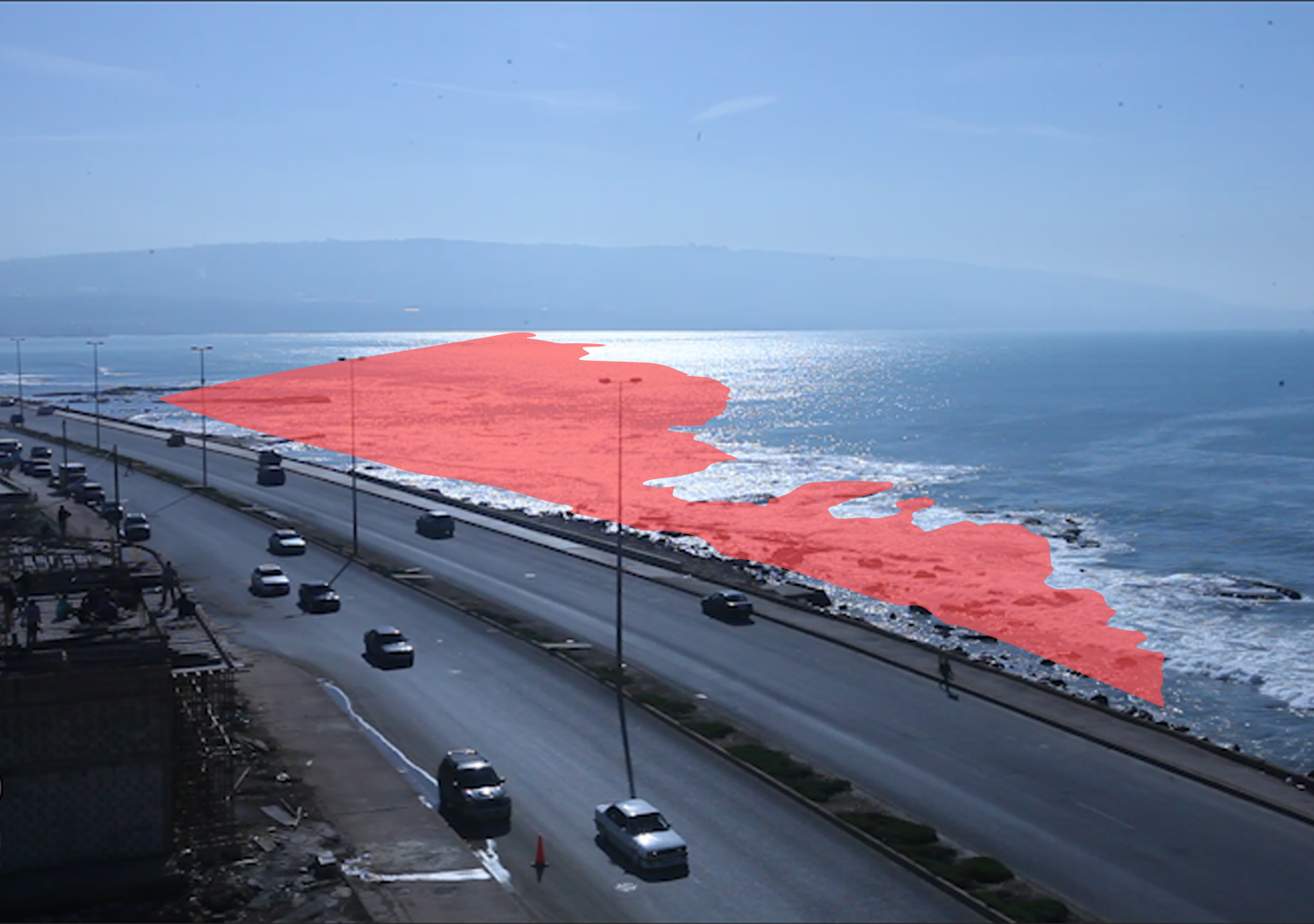
In 1935, Property No. 220 in the Basateen El Mina area was entered into the Land Registry as part of demarcation and drafting activity. The cadastral map of the property showed that it is bordered by “maritime rocky land”. The map suggests that this is a section of land falling under maritime public property per Article 2 of Decision no. 144/س issued in 1925, which deems the seashore extending up to the furthest point that the waves reach in winter, as well as the sand and gravel beaches, to be public property.
This situation remained stable and undisputed because it was completely in keeping with not only the law but also the property’s topography (the sea, waves, sand, and land which determine its status as public property). This can be seen every day, especially during rainfall, when the sea encompasses the entire section, turning it into no more than a surface of water.
The Judiciary Protects Public Property in the Pre-War Era
In 1969, members of the al-Shabtini family – the heirs of Francis al-Shabtini – filed erroneous claims to the additional real estate judge in North Governorate contending that a material error had occurred during the demarcation and drafting process and, consequently, a section of land west of Property No. 220, which they own, had been [incorrectly] classified as maritime property. They asked that the error be corrected, that an expert be appointed to carry out the demarcation and drafting procedures for the plot lying between Property no. 220 and the sea (the section that the cadastral map referred to as “a piece of maritime rocky land”), and that it be given a new number and registered under their name in the Land Registry on the basis of Article 15 of Decision no. 188/1926 (On Establishing the Land Registry). The area of land encompassed by the claim was 58,000m2. They alleged a material error to circumvent the principle that the results of demarcation and drafting cannot be contested after two years have elapsed since the estate’s registration in the Land Registry.
After studying the case file and verifying that the regular real estate judge’s decision contained no ambiguity requiring interpretation and that there was no material error requiring correction, the additional real estate judge issued a ruling dismissing the claim on account of lack of absolute jurisdiction.[1] The decision was also upheld in the Court of Appeal in 1971.[2] In 1987, after the plaintiff party filed a petition for cassation against the appellate decision, the General Body of the Court of Cassation issued a principled decision deeming that decisions issued by the additional real estate judge are not open to cassation before it.[3] Hence, it is perfectly clear that this section of land was established as public property not only by virtue of nature, the law, and the cadastral map, but also by judicial rulings (i.e. the force of res judicata, meaning a matter already adjudicated).
The Ministry of Public Works Abandons State Property During the State’s Collapse: The El Mina Case as a Gauge of Ministers’ Integrity
The following efforts were made via the Ministry of Public Works because the protection and administration of public property falls within its competence. Upon reviewing the series of stances adopted by these ministers, we can say that the story of this fake property serves as a measure of their concern for public property. Those who refused to endorse the fiction displayed a high degree of integrity in this regard, whereas those who treated it as truth even though they knew it was fiction were – with no exaggeration – intentionally derelict in their responsibilities and therefore breached trust. Of course, the minister’s integrity became a decisive factor once the personal administration of public affairs gained precedence over the principles of institutional work, particularly amid and after the Lebanese Civil War (1975-1990).
This chapter begins in the late 1980s. In 1988, under one of the war governments, the heirs of the al-Shabtini family filed a request to the secretary of the Land Registry in North Governorate to correct the material error stemming from inconsistency between the demarcation and drafting map and the title deeds. They argued that this map did not state that the western border of the property surveyed as no. 220 is “the sea” and that the western border that appears on the final cadastral map is a straight line, meaning that the section of land between the western border and the sea remained separate from the main property. At the time, the secretary sent a memorandum to the head of the Cadastre Bureau in Tripoli requesting that he develop a map and clarify the situation. The Cadastre Bureau organized the necessary chart.
Meanwhile, the heirs submitted a petition to Walid Jumblatt, the minister of public works at the time. On 17 September 1990, Jumblatt approved the heirs’ request and sent a letter to this effect to the Secretariat of the Land Registry in North Governorate. The letter asked the secretariat to correct the material error and deem the section labelled “maritime rocky land” a part of Property no. 220 – Basateen El Mina, number it on the cadastral map, and register it under the name of the al-Shabtini family heirs in the Land Registry. Although the secretary of the Land Registry asked Jumblatt to send the request to him via the Ministry of Finance and the General Directorate of Land Registry and Cadastre, Jumblatt instead sent a request for consul to the Legislation and Consultation Committee. In May 1993, this body issued an opinion deeming that the petitioners’ request cannot be accepted. It justified its stance on the basis that the existence of a material error cannot be reinvestigated, especially administratively, because of the force of res judicata carried by the appellate ruling. After detailing the grounds of both the first instance and appellate decisions issued in this case, the committee explained that the request filed to the Ministry of Public Works resembled the request previously filed to the additional real estate judge (i.e. to correct the alleged material error).
The heirs of the al-Shabtini family did not relent. They tried once again in 1994 when the Minister of Public Works and Transport was Omar Meskawi, filing a new request to “correct” a material error concerning Property no. 220 – Basateen El Mina. They attempted to demonstrate that there was no res judicata and that this request was different from the previous court case. They argued that the subject of the request filed to Meskawi was to correct a material error concerning the western border of the property such that it corresponds to its position in the demarcation and drafting record, whereas the court case was based on there being a section of the property that was incorrectly incorporated into public property and must be demarcated again under the name of the heirs. Clearly, the two claims are identical, and the heirs’ argument was a sophism.
The first measure that Meskawi took was to refer the case for study by a surveying expert. Based on the expert’s report, the minister’s response followed the same vein as the judiciary and the Legislation and Consultation Committee. His letter dated 8 February 1996 stated, “It has become impermissible to reexamine, especially administratively, whether such a material error exists because of the force of res judicata carried by the appellate ruling issued on 11 February 1971 with regard to its dismissal of the correction request because the regular real estate judge’s decisions contained no material error requiring correction… consequently, it is no longer possible to examine a request to correct a material error that, judicially, has been categorically proven not to exist”. In May 1996, the minister sent a second letter to the heirs’ attorney warning against inducing the Secretariat of the Land Registry to take actions that contravene the law. While the heirs argued that the land under dispute is “rocky” and part of the landmass, and that the material error stems from discrepancy between the demarcation record (which they claim stated that the property’s western border is the sea) and the cadastral map (which indicated that the western border is a hypothetical straight line of maritime rocky land), Meskawi denied that there was any discrepancy between the two records because the word “sea” [bahr] means all maritime [bahriyya, or “sea-related”] properties; therefore, the rocky area deemed maritime property is part of the sea and not the landmass. The letter also stated that maritime public property is defined not only by the crash of the waves, but also by the natural factors arising from the concept of the shore and its overall view. It added that the seashore and its sands are classified as conserved places and spaces and that they are essential for preserving biological balances, they provide biological benefit, and they are a feature of the shore’s natural and cultural heritage. Meskawi thereby blocked the attempt to privatize the shore, invoking not only res judicata but also the nature of this land, its close connection to the sea, and, subsequently, its ineligibility for privatization. The Legal Agenda learned from a reliable source that Meskawi, with his integrity and “clean hands”, maintained his position even though he was offered lucrative enticements in 1996. The source requested that we not disclose their name or the details of these enticements.
The heirs of the al-Shabtini family and those behind them did not abandon the effort. Hence, after a break lasting over a decade, they had high hopes after the removal of Meskawi as minister of public works and the appointment of Ghazi Aridi. In 2010, they again filed a request, this time to Aridi, repeating their previous claims. At this point, the story begins to take a surprising turn. Aridi seemed to turn a blind eye and disregard the file kept in the ministry and the documents therein, most notably Meskawi’s letter, the final court rulings, and the Legislation and Consultation Committee’s advice. He also disregarded his role in protecting public property, instead exploiting that role to enable the heirs and those behind them to appropriate this enormous area in exchange for nothing. To avoid any possible thwarting, this time Aridi did not turn to the Legislation and Consultation Committee; rather, he turned only to the Cases Department within the ministry, whose strings he could pull. As expected, the department agreed with the request and ultimately deemed the western section located between the corniche, the highway, and the sea border a part of Property no. 220 – Basateen El Mina owned by the al-Shabtini family.
Accordingly, the minister sent a letter to the Secretariat of the Land Registry in North Governorate asking that the “material error” be corrected by numbering and registering a [supposed] section of Property no. 220 under the name of Francis al-Shabtini’s heirs,[4] as though it were an independent property. However, the secretary of the Land Registry refused to implement Aridi’s request and sent a letter to then-minister of finance Raya Haffar El Hassan to examine the matter and take the appropriate action.[5] On her part, the minister of finance demonstrated high integrity, refusing to “correct” the records pursuant to an administrative letter and deeming that the administration’s intent was for all the property west of the Boulevard and bordering maritime property to be public maritime property. She also deemed that the minister of public works’ insistence on implementation does not bind the administration nor the Secretariat of the Land Registry. In actuality, the heirs were not able to transfer ownership of the property, and their demand was rejected for the fourth time.
Despite the refusal by the minister of finance to transfer the property registration, Aridi did not desist from allowing people to appropriate areas that he, as a minister, was entrusted with protecting. This time, the al-Shabtini heirs went hand-in-hand with Aridi to the judge supervising land-pooling and subdivision in North Governorate, Nazih Akkari. In fact, this judge had no jurisdiction whatsoever over the matter, as the area in question had been registered as public property since 1935 via demarcation and drafting and was never part of any subdivision. Aridi sent a written request to the aforementioned judge asking him to “take the necessary legal [action] regarding Property no. 220 – Basateen El Mina, and number and register it under the name of Francis al-Shabtini’s heirs in the Land Registry”. Remarkably, Aridi had no qualms about sending the request without any explanation, not even to provide himself with legal cover. He apparently hoped that everybody, including the judge, would turn a blind eye to public property so long as he – the person responsible for protecting such property – had no qualms about doing so.
In May of the same year, the heirs filed a petition before the same judge, repeating their previous claims. Less than a year later, in February 2014, the judge issued a decision deeming the property concerned a plot owned by Francis al-Shabtini’s heirs but was inadvertently omitted [from the records].[6] The plot was to be 29,838m2 in size, which is approximately half of the area that the heirs had demanded in 1969. The decision asked the secretary of the Land Registry in North Governorate to register the plot on the title register of Property no. 220 – Basateen El Mina. Although the judicial decision did not mention numbering this property as a “new” property and instead joined it to Property no. 220, in December 2015, when it was registered in the Land Registry and its certificate issued, it was given the number 1403. In other words, it was registered as a newly created property independent of Property no. 220.
Thus, a fake property was created in the sea and privatized with direct support from the Ministry of Public Works. How did the citizens confront this privatization and disrupt the corruption? What is the outcome of the cases? This we shall address in the second part of this article.
This article is an edited translation from Arabic.
Keywords: Public space, Public property, Lebanon, state corruption, Ghazi Aridi, Raya El Hassan
[1] Ruling issued by the additional real estate judge in North Governorate on 21 March 1969.
[2] Ruling issued by the Court of Appeal in North Governorate on 11 February 1971.
[3] Ruling issued by the General Body of the Court of Cassation, no. 1, 2 April 1987.
[4] Letter from Minister of Public Works and Transport Ghazi Aridi to the Secretariat of the Land Registry in North Governorate, issued 24 February 2010, No. 236/ ص.
No. 236/ص, February 24, 2010.
[5] Letter from the secretary of the Land Registry in North Governorate to Minister of Finance Raya Haffar El Hassan, no. 2081, 8 June 2010.
[6] Decision no. 21/2013, issued by the judge supervising land-pooling and subdivision activity in North Governorate, 26 February 2014.