Planning Zouk Mikael: Ignoring the Power Plant of Death

Anyone passing between al-Kalb River (Nahr al-Kalb) and Jounieh cannot miss the sight of two columns, striped orange and white, rising into the sky from the Zouk Mikael seafront. Though they are a landmark of the region, the sight appears on no postcards. The two columns are symbols of death, the smokestacks of the power plant that has threatened the town’s residents since 1983.
The plant began as a gas power station in 1956. However, it quickly transformed into an environmental disaster.[1] It also failed to meet the region’s electrical needs. Despite the health risks the plant poses to the residents,[2] the area surrounding it has witnessed a rush of construction projects and rising population density. The Black Book documents the objections, complaints, suffering, and movements of the townspeople and the pressure the mayor placed on the ministries concerned to solve the problem.[3] To this day, the plant continues puffing its poisons, the most recent action by the region’s people having occurred at the beginning of this year. This article will examine the municipality’s planning role and the possibilities for its intervention in the town’s planning to reduce the plant’s dangers. We will also study the course of urban development in Zouk Mikael and the urban vision that may have prevented the “death plant” from being properly addressed.
The Refuge Suburb
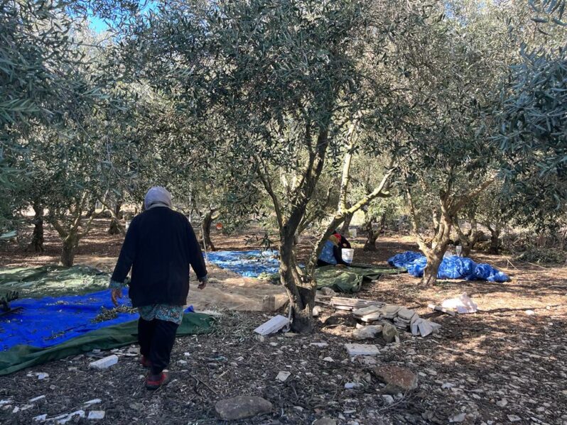
Zouk Mikael lies fourteen kilometers from Beirut and stretches from the sea to the hills, the highest of which peaks at an altitude of 275 meters. Historically, the area was renowned for agriculture. Its fertile coast is irrigated by al-Kalb River, and its heights – cultivated with almond, olive, berry, and vine trees – are irrigated by several springs, such as Ain al-Zouk and the spring of Wadi Hantouch, which separates it from Bkerké.[4] The town was famous for producing silk and eatables and for its lively market of loom knitting, shoemaking, blacksmithery, and goldsmithery. Benefiting from its proximity to Jounieh’s port, which facilitated importation and exportation, the market was one of the largest in the Keserwan region.[5] Although commercial activity based on agriculture and industry declined because of global competition (especially in artificial silk production), emigration resulting from the First World War, and, later, local competition centered in Beirut, the town’s economy only really transformed during Lebanon’s 1975-1990 Civil War. However, the foundations of this transformation were laid in the 1960s, as we shall see.
In 1923, the town’s population numbered 1,666. Most of the families are Maronite and Catholic, though there are also Syriac and Armenian Catholic families.[6]
The region began to expand with the real-estate projects pioneered by Gallina Duraffourd, the wife of Camille Duraffourd, a French official that the French authorities vested with developing the new land registration and cadastre system in Lebanon during the mandate.[7] Gallina assumed the function when her husband died in 1941 and served until 1943. In 1953, Gallina established, in partnership with Lebanese businessman Michel Zoghzoghi, the “Lebanese Company for Real Estate Improvements s.a.l. – SLAF”, which carried out numerous housing projects in Baouchriyeh, Antelias, Brummana, Aley, and Zouk Mosbeh. This company was the first in Lebanon to carry out land-pooling and subdivision projects, lay roads, and bring water, electricity, and phone lines to the subdivided properties and then sell them.[8]
One of these projects is “Adonis Centre”, situated in Zouk Mosbeh (the area bordering Zouk Mikael) and inaugurated in June of 1961 as “a city for the future”. The residential project was erected in the pine forest as the ideal refuge for those working in the city who longed to escape its noise and pollution to enjoy the tranquility and healthy climate in a breathtaking suburb situated between the sea and the mountain, only minutes away from the capital Beirut, 300 meters from the freeway completed in 1959. The project consisted of 400 properties. Prices ranged from US$4 to $6 per square meter, and there were facilities for payment via installments over three years for property purchases and eight years for construction.[9] The minimum salary at the time was US$95.[10]
In line with the vision developed in the late 1950s of Zouk Mosbeh as a model residential suburb, the mayor of the neighboring Zouk Mikael municipality lawyer Nouhad Naufal devoted attention, from his election in 1963, to the construction, subdivision, and infrastructure regulations in order to attract real estate investment. Naufal wanted a model suburb that was “characteristically European with its cleanliness, gardens, and development without losing the spirit of a Lebanese village”. Hence, he immediately classified the town as “under study” in order to review its circumstances in preparation for issuing the first general master plan in 1973.[11] The plan encompassed both the Zouk Mosbeh and Zouk Mikael towns.
This general master plan sketched a vision for expanding the town, specifying residential areas that overlooked the power plant and featured high exploitation ratios (exploitation ratios dictate the permitted size of a structure given the size of the underlying property), as well as the conditions for the distribution of industrial and commercial establishments in all areas. It also specified an industrial area around the plant on the coast under the freeway where the agricultural lands were located, as well as a commercial and services area for the construction of cinemas, entertainment venue, restaurants, and cafes. With the change in the usage of the coastal agricultural lands, the purchase and rental of properties began – properties many of which were owned by monasteries or were religious endowments (awqaf).[12]
During this period – i.e., before the 1975-1990 Civil War – most of the town’s residents were from Keserwan’s highlands, such as Mayrouba, Hrajel, Faraya, and Kfar Dibiane. They came to the town during winter to work and study. Similarly, most of the electricity company’s employees were residents of the town.[13]
When the war began and the capital Beirut collapsed, the town gained an opportunity to stimulate commercial activity connected to real estate investment, entertainment, and services. The fact that the 1973 general master plan had laid the foundations for a “Las Vegas”[14] on the town’s lands, particularly its coast, was a contributing factor.
“Las Vegas”
The town’s population greatly increased during the war. The Keserwan region saw one of the largest urbanization processes in Lebanon, attracting people displaced by the battles in Beirut and in North Governorate, particularly the Christians.[15] The 1995 census indicates that the town’s population had reached 30,000 people spread across 4,500 residential apartments.[16] Besides the role of the general master plan, which planned this enormous urban expansion, the region’s historical connection to Christians played a role in attracting the new the residents. From a conservative Christian perspective, Keserwan’s history is full of indications of the threat to the Christian presence in the Near East, particularly the fall of the “Lebanese Christian resistance in Mount Lebanon”, specifically the “Marada forces”, to the Mamluks and Arab rule in 1305. The Mamluks settled the Lebanese coast in order to repel crusader attacks. It is remarkable that the vocabulary and labels used to refer to the Christian factions participating in the Civil War trace back 700 years.[17]
This identity as a minority preserving its independent existence still influences the vision for the future of the Keserwan region and the town. Today, the poison-spreading power plant seems to Christians, by virtue of the self-sufficiency it could provide to the region in any future confrontation, like a vital facility and economic pillar. Note that the National Physical Master Plan of the Lebanese Territory recommended reducing the number of electricity production sites in Lebanon and shutting down the town’s plant, which is no longer environmentally suitable.[18]
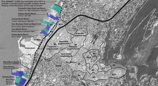
As the population influx during the war was occurring, the largest encroachments and building violations occurred on the shore from northern Beirut to southern Tripoli.[19] In Zouk Mikael there were two resorts in violation at the time – Samaya and Solemar – the latter being the greatest violation in terms of its area.[20] The development of recreational areas on the shore in parallel with the urban development helped spur demographic change and political repositioning. Similarly, the possibility that merchants of war could launder their money through the real estate sector, as well as the inflation that inflicted the currency and the subsequent lucrative opportunities for purchasing property at low prices, exacerbated this phenomenon. These resorts, with their small chalets, constituted a refuge for the people of Beirut fleeing bombardment.[21]
In 1998, in order to free the shore from industrial areas to make way for tourist establishments and services, a new general master plan was issued for Zouk Mikael, this time independently of Zouk Mosbeh. The new plan shrunk the industrial area in which the plant is situated and attached the lands to the services-commercial area where the resorts and the remaining agricultural lands are distributed.
As for the planning of the residential areas, the exploitation ratio was reduced or the conditions for land use amended in four such areas, all located in “upper Zouk”, i.e., on the hills far from the plant (see details in the chart). As for “lower Zouk”, the new plan retained the high exploitation ratios set in the previous general master plan (1973). Those exploitation ratios are among the highest found in coastal areas with similar geography. If the al-Mir, al-Kharouba, al-Central, al-Bustan, and Sakhr neighbors, among others located in the lower section, are the most harmed by the plant and pose a threat to their residents’ health and interests, why did the new master plan encourage more construction in these areas?
In an interview we conducted with Elias Beaino, the municipality’s current mayor and the deputy to former mayor Nouhad Naufal (who served for 53 years), he stated,
Exploitation remained the same, but there is certainly a health problem for the people living in the town. Lands, especially those closest to the plant, have become cheap because of the pollution, and unfortunately, construction has become a business – anyone who takes land profits. We can confirm that the highest rates of pollution and respiratory diseases are here in Zouk Mikael. We have a report by experts and a report from the region’s hospitals.
It seems that the lower section has been abandoned to investments and the construction business as the properties have lost much of their monetary value because of the pollution, as the mayor explains. However, the municipality is actively planning the upper section and intensifying the conditions that render its residential areas safe and luxurious. It seems that the dream of the refuge suburb has been transferred to the town’s heights, where only the construction of large apartments and villas is permitted. While the dream of a quiet and healthy environment in the 1950s and 1960s was attainable for a larger percentage of residents, today this dream has become one restricted to a wealthy minority, a dream achieved through master plans that limit population density in the safest and healthiest areas while encouraging construction and higher density in the areas that pose the greatest risk to people’s lives.
“Monte Carlo”
Today, approximately 35,000 people reside in Zouk Mikael, among whom only 4,000 are registered to vote in the area and therefore able to participate in municipal elections.
Most of the residents suffer from respiratory diseases, and each one has their story of coexistence with the plant. Zeina says, “We moved to the town when I married. We closed the balcony doors and the windows. We bought a dryer and began hanging our washing inside”. Conversely, the urban vision endeavors to turn the town into a “Monte Carlo” (according to the municipality) this time. The resorts that usurp public property are on the increase, and constructing towers on the coast is one of the municipality’s most important plans for developing the town.
The general master plans for the Zouk Mikael municipality express two orientations that may seem contradictory at first glance. The first is the protection of heritage and preservation of traditional industries, and the second is an economic vision based on services and real estate investment. However, the two visions are in harmony and complement each other in marginalizing the productive local economy that distinguished the region and in converting its natural resources and heritage into a commodity consumed by tourists and the wealthy without benefiting its residents. While this orientation may resemble the general trend among many Lebanese cities and towns, in Zouk Mikael it has compounded marginalization. For within this eager vision that the municipality sketches far away from the residents, there is no place for urban planning that takes into account the people’s real problems and spares them from the risk of death.


This article is an edited translation from Arabic.
Arabic article available here.
This article was originally published in Arabic as part “Master planning in Lebanon: Manufacturing of Inequality” (July 2018). This publication is the outcome of a research project by Public Works Studio in collaboration with the Legal Agenda.
Related articles:
To Pit Agriculture Against Tourism: The Case of the Zahrani Coast
The Legislative Framework for Urban Planning: No Voice for the People
Master-Planning in Lebanon: Manufacturing Landscapes of Inequality
[1] Patrick El Kallas, “The Zouk Powerplant: Health Impacts and a Feasibility Study of Solutions”, MSC in Energy, Heriott Watt University, August 2010.
[2] Issam Lakkis, Najat Saliba, and Samer Salloum, “PM10 Pollution Caused by the Zouk Mikael Power Plant”, 2014.
[3] The Black Book (al-Kitab al-Aswad) is a publication issued by the Zouk Mikael municipality reviewing the power plant’s situation and the residents and municipalities’ movements over the years.
[4] Tony Mufarrij, Mawsu’a Qura wa-Mudun Lubnan, vol. 13, Dar Nubilis.
[5] Zuq Makayil: Azmat al-Hudur fi Tarikh Lubnan, vol. 2, Antoine Salama, Dar Maktab Nawfal – Zouk Mikael, 1977.
[6] Zuq Makayil: Azmat al-Hudur fi Tarikh Lubnan, vol. 1, Antoine Salama, Dar Maktab Nawfal – Zouk Mikael, 1977 (the statistics rely on the Zouk Mikael municipality’s archives – municipal fees register).
[7] Adib Fares, “The Cadastral System in Lebanon Comparing to the other International Systems”, paper presented in the 22nd International Congress of Surveyors, Washington, D.C., April 2002.
[8] Revue du Liban, 22 July 1961.
Jean-Pierre El Asmar, “Sustainable Rehabilitation of the Built Environment: The Case of Coastal Area of Zouk Mosbeh, Lebanon”, PhD De Montfort University, 2008.
[9] Ibid.
[10] Louis Hobeika, “Tashih Haykaliyyat al-Iqtisad al-Lubnaniyy”, Bawwabat al-Sharq al-Iliktruniyya, 2011.
[11] Zuq Makayil: Azmat al-Hudur fi Tarikh Lubnan, vol. 2.
[12] Interviews with residents and a review of some real estate newspapers.
[13] Interviews with residents.
[14] Zuq Makayil: Azmat al-Hudur fi Tarikh Lubnan, vol. 2.
[15] Eric Verdeil, “Entre Guerre Et Reconstruction: Remblais Et Empietements Littoraux A Beyrouth”, 2002 – in Goeldner L., Velut S., Yellès-Baron N. (coord.), Le littoral. Mélanges en hommage à Fernand Verger, Paris, Presses de l’Ecole Normale Supérieure.
[16] Zuq Makayil: Azmat al-Hudur fi Tarikh Lubnan, vol. 1.
[17] Andre Khale, “Marhalat Inhiyar al-Muqawama al-Masihiyya – Hamlat al-Mamalik ‘ala Kisirwan (1305)”, Hay’at al-Thaqafa al-Siryaniyya (Syriac Culture Body) publications.
[18] The National Physical Master Plan of the Lebanese Territory was issued via Decree no. 2366 in 2009. The final report was issued in November 2005 by the Council for Development and Reconstruction in cooperation with the Directorate General of Urban Planning.
[19] Eric Verdeil, “Entre Guerre Et Reconstruction”.
[20] Localiban, Local Development Resource Center.
[21] Eric Verdeil, “Entre Guerre Et Reconstruction”.