Master-Planning in Lebanon: Manufacturing Landscapes of Inequality

During the past decade, many researchers have studied the relationship between geography and law in an attempt to clarify the links between these two increasingly complex concepts. In reality, comparing law and the built or natural environment can alter our understanding of both and may pose new questions about how to produce cities, sustain them, or change their course.[1] In Lebanon, the prevailing view of the law has usually ignored its social dimensions and reduced it to the mechanism whereby the political class exerts influence via legislation. The effect of this on the course of urbanization, development, and the environment has been enormous. When we look at the institutional landscape, present and past, we find a complete failure in handling the environment and urbanization. For many decades, Lebanon has witnessed a deterioration in housing rights, the closure of its beaches to the public, and the absence of a public transport plan, not to mention the increasing borders and barriers between areas and around neighborhoods and the disappearance of open and green spaces from our lives day after day. The previous and current urban policies have disrupted people’s day-to-day lives, distorted their built and natural surroundings, and constricted their ability to participate in the decisions that directly affect them.
In this context, in July 2017, Public Works Studio, in collaboration with The Legal Agenda, launched a research project titled “Urbanism and Law in Lebanon: General Master Plans and Their Impact on Everyday Life”. We took a critical look at the land use maps (i.e., the general master plans) in 15 cities and towns in Lebanon, from the far north to the far south: Zgharta, el-Mina, Chekka, Hsoun, Kousba, Berbara, Zouk Mikael, Dbayeh, Damour, Dibbiyeh, Baakleen, Adloun, Aabbassiyeh, Nabatieh, and Qana.
After a year of interaction with people and places – sometimes unfamiliar to us – it is not easy to draw lessons or conclusions. The process of writing about this topic is not much different from the research process itself as the experience is a mix of contradictions, anger, and contemplation that, in the beginning, paralyzes all our thoughts.
Where do we begin? Initially, we find people’s lives shattered and distorted – either covered in the dirt of a long war or surrounded by the odor of pollution or a sense of loss stemming, for example, from losing a home, location, or source of income.
But we quickly become aware that the individual and collective suffering we witnessed during our research in these places, and the situation usually dubbed chaos, is not arbitrary or imposed by reality. Rather, it is largely a result of poor planning or a defective vision. On the other hand, the dominant political discourse has long stated that all our contemporary problems are a result of the 1975-1990 Civil War, which helps ward off a critical perspective on the urban policies or orientations that prevailed before the war. In several cases we documented, we conclude that the current poor planning has roots extending back before the war.
Planning in its Beginnings
In the 19th century, an obsession with strict order and a desire among the middle class to preserve the cleanliness and image of the city launched from Europe and the colonial powers. Urban space was allocated and zoned in a manner ensuring that the “mistakes of urban life” do not threaten the new, well-ordered system.[2] With the advent of modernity, planners attempted to materialize the state’s dream of physical order and political stability via their organization of urbanization.[3] Hence, the construction and zoning laws led to the division of the city in a manner that reproduced and reaffirmed class divisions.
In France under the Second Empire, Baron Haussmann’s planning of Paris (via the demolition and restructuring of neighborhoods) was not just a direct act of counterrevolution; rather, it was also a symbolic act aimed at disassociating the streets of Paris from their revolutionary history and propelling real estate speculation.[4] Given such policies, urban planning was, from its outset, an integral part of the “modernist project”.[5] Planners, and people in general, saw urban planning as a means to achieve a uniform conception of “public good” by making use of the knowledge of experts to enable the state to shape the urban environment. Other, local forms of knowledge that had shaped environments in the past were thereby disregarded. “Planning” was institutionalized in a manner concordant with the prevailing ideologies and ruling regimes and thus became a tool for controlling how urban space takes shape in line with the understandings and values of the government and the elites and groups affiliated with it, all in the context of unprecedented urbanization and capitalism endorsed by all institutions.
In Lebanon, planning and envisioning the city was also part of the experience of modernity.[6] Modern landmarks were constructed to promote a new understanding of society as something that advances, develops, and modernizes. However, the liberal commitment that characterized Lebanon in 1943 put it in direct contrast with the policies adopted in the post-colonial states, especially with regard to the establishment of planning institutions and the promises to produce a modern welfare state. In Lebanon, the dream was not connected to the welfare state;[7] rather, the promise was that we would be, in particular, a service-producing country, as stated by lawyer Gabriel Menassa in a speech to the Lebanese Association for Political Economy in 1948: “Commerce, tourism, and the frequent coming of foreigners constitute the primary nerves of our economic system”.[8]
Hence, the early 20th century witnessed the enactment of the Lebanese Construction Law in 1940, the result of a process of updating and rewriting the French law. This process was carried out by a committee of architects who had lived and studied in Europe under the modernist approach that existed at the time, and the law’s text reflected the individual intellectual paradigms of each of the committee’s members.[9] This elitism (according to Marwan Ghandour) entrenches the hierarchical position of experts vis-a-vis urban space and places the Lebanese Construction Law as an extension of the modernist-colonialist project. In addition, the Construction Law was an expression of the service and tourism-based orientation of the economy, for it strived to intensify construction via a computation of exploitation ratios in much the same fashion in all areas of Lebanon, ignoring various factors such as the composition of the land, geography, and society.
Years later, with the eruption of the 1958 war, many of the public institutions known to us today began to form and endeavored to intervene directly in planning the country’s urban space.[10][11] Discussion about the “National Development Plan” began in the 1950s with the establishment of the Ministry of Planning. The year 1962 witnessed the issuance of the first urban planning law, which was followed by the planning of 82 areas in Lebanon (i.e., general and detailed master plans were issued for them) within the 15 years preceding the 1975-1990 Civil War.
However, the disintegration and weakening of the central state during the 1970s led to the state’s near-terminal collapse with the eruption of the Civil War, as well as the abolishment of the Ministry of Planning in 1977.[12] Since 1990, Lebanon has strived for large-scale reconstruction projects, claiming that it is returning to its early liberal commitment regarding limited state intervention in social and economic affairs. In an attempt to attract international financial elites, most of the interventions have focused on making astonishing improvement to the physical infrastructure, as well as large-scale reconstruction of the center of the capital.
The National Development Plan was only put in place more than half a century after discussion about it began, and it was reduced to the National Physical Master Plan of the Lebanese Territory (NPMPLT). The NPMPLT’s objectives were to advance the principle of equitable (economic) development of regions, distribute services and facilities, and rationalize resource use. It was issued via decree in 2009. On the other hand, in 2000 a law was issued to abolish the Ministry of Housing and Cooperatives and the Ministry of Municipal and Rural Affairs, ending any official talk about the right to housing and equitable development.
Since 1990, the Directorate General of Urban Planning (DGUP) has issued general master plans for 78 areas, which means that in the 28 years following the war, fewer areas have been planned than during the 15 years preceding it. The DGUP issues plans and regulations for each city, village, and town individually, without overall direction or a general policy and without any mention of the NPMPLT.
On What Basis, Then, Are General Master Plans Issued?
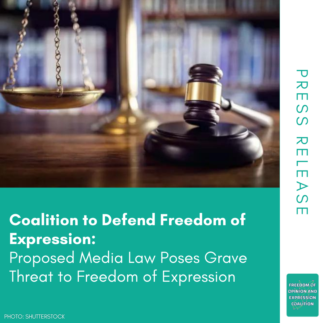
In the southern town of Qana, the residents wonder why nobody ever asked about them before the massacre they suffered as a result of the Israeli offensive in 1996. After the massacre, this obscure town came under the spotlight. Light was thereby shed on the cave said to be the location where Jesus first performed a miracle and the importance of protecting the site in this unplanned town. Hence, the DGUP took the initiative to work on a general master plan for Qana for the very first time. The plan was limited to protecting the cave and satisfying the desires of the influential people in the town. It classified the hilltops as “villa” areas and prohibited construction around these villas so that their owners could enjoy the view of the trees and the serenity.
In the first section of this publication, we try to form a historical understanding of the impetus behind issuing general master plans and the legal framework surrounding this practice. In this section on legislation and reality, Marwan Ghandour’s article shows the history of the planning of Baalbek. The planning of this city is an example of the contradiction between legislation and social-spatial practices, a contradiction that manifests itself in the deterioration of the urban fabric and the quality of space in the city.
In the four subsequent sections, we focus on the consequences planning has on people’s lives. In each one, we derive lessons about urban planning practice in Lebanon.
The second section addresses exclusionary practices, starting with the stories of Damour and Dibbiyeh, where we explore how local authorities have handled historical realities such as the Civil War. In the Chouf region, which witnessed the massacres and atrocities of the Civil War, residents found themselves wondering whether they would ever return. Since then, local politicians have exploited the painful past to express modernist, fear-inducing discourses that lead to further exclusion. Hence, general master plans have been developed on a classist basis whereby undesirable residents are those unable to afford to reside in or enter these new projects. In Hiba Bou Akar’s article about the Sahra Choueifat, she explains how planning geographies of war in “peacetime” helped produce the events known as “May 7”. The article explains how the production of the everyday geographies of life, such as housing, roads, and industrial areas, by sectarian political organizations transformed the city’s marginalized outskirts into new battlefronts.
In the towns of Zouk Mikael and Chekka, we find people wiping the dust off the potted plants, floor, and furniture of their homes, dust that accumulates day after day because of the industrial facilities next door. They frequent the hospitals because, after all their protests and activism over the years, doing so is the only way to mitigate the effects of the poisons penetrating their chests. In Zouk Mikael, the residents repeat the narrative told by the municipality, which claims that it has no role in finding a solution to this problem even though the consecutive municipal councils have not resisted the general master plans that encourage further construction in the residential neighborhoods most harmed by the industrial areas. Via the cases of Zouk Mikael, Chekka, and Hsoun, the third section raises questions about the historical context of the rise of the industrial areas and how consecutive general master plans have threatened public health.
This ignoring or covering-up of reality is not limited to industrial areas. Rather, it also encompasses the informal settlements that have existed for many decades. In the fourth section, we relate how the residents of the Chabriha neighborhood watch as the tractors of the Council for Development and Reconstruction demolish their neighbors’ homes to complete the southern highway. In Rana Hassan’s article “Exclusionary Regulations and Informal Urbanization: The Case of the Palestinian Community in Nahr al-Bared”, an analysis of the historical development of the extension of the Nahr al-Bared camp shows how urban planning helps marginalize the Palestinian refugee community, once again proving that planning regulations can be political tools for excluding people and depriving them of certain rights.
On the Zahrani coast, the residents of Adloun wonder, why has the area not received development interventions since the formation of modern Lebanon? Why is the vital economic driving force of the Zahrani plain (two thirds of the area was traditionally used for agriculture) being marginalized? In her article about the shore of the city of Tyre, Nathalie Bekdache approaches similar questions about the relationship between clientelism and conservation or lack thereof of local resources. In this fifth and final section (and via examples from Dbayeh and Sidon), we witness how clientelism and private interests take precedence over history and local resources via an intentional legislative vacuum.
In all these cases, planning, in its practice, remains a tool of the powerful, whether they be the central state, the wealthy, or the social elite. Consequently, all rights – the right to health, to dignified reconciliation, to housing, and to development – are violated. These general master plans have therefore helped do away with people’s imagination, the fabric of places, ways of life, and, sometimes, entire neighborhoods.
Is the practice of planning in Lebanon still rooted in a modernist vision that presents a clean, orderly image at the expense of the undesirable classes? Or is it a neoliberal practice rooted in free market policy via the logic of granting exemptions from the law, which has become a main tool of planning? Or does the current, non-participative legislative framework exacerbate the power of decision-making circles that are restricted to personal relationships and pave the way for the rise and spread of corruption in the form of nepotism and clientelism?
In this publication, we try to answer these questions, which we hope will constitute a starting point for further discussion and direct action.
This article is an edited translation from Arabic.
Arabic article available here
This article was originally published in Arabic as part “Master planning in Lebanon: Manufacturing of Inequality” (July 2018). This publication is the outcome of a research project by Public Works Studio in collaboration with the Legal Agenda.
Related articles:
1. To Pit Agriculture Against Tourism: The Case of the Zahrani Coast
3.Planning Zouk Mikael: Ignoring the Power Plant of Death
5. The Legislative Framework for Urban Planning: No Voice for the People
[1] Clark, T. J. (1985), The Painting of Modern Life: Paris in the Art of Manet and his Followers, London: Thames and Hudson.
[2] Ibid.
[3] Prendergast, C. (1992), Paris and the Nineteenth Century, Cambridge, MA; Oxford: Blackwell.
[4] During the uprisings of 1789, 1830, 1848, and 1871, parts of Paris surrendered to the revolutionaries. These successes were in part due to the narrow, winding corridors in the city, which traced back to the Middle Ages. Haussmann’s renovation of Paris was an enormous program commissioned by Emperor Napoleon III. It involved demolishing neighborhoods from the Middle Ages that the government at the time considered crowded and unsanitary, constructing broad roads and new gardens and squares, and annexing the suburbs surrounding the city.
[5] Yiftachel, O. (2000), “The Dark Side of Modernism: Planning as Control of an Ethnic Minority”, in The Blackwell City Reader, Blackwell, Oxford, p. 535-541.
[6] Hanssen, J. (2005), Fin-de-Siècle Beirut: The Making of an Ottoman Provincial Capital, Oxford: Oxford University Press.
[7] Abu Rish, Z. (2015), “Then and Now: Lebanese State Institutions During the Early Years of Independence”, interview on LCPS.
[8] Menassa, G. (1948), Plan de Reconstruction de l'Economie Libanaise et de Reforme de l'Etat. Avec la collaboration de M. Joseph Naggear, Beyrouth: Éditions de la Société libanaise d'Économie politique.
[9] Ghandour, M., “Building Law: A Critical Reading of the Lebanese Case, in Paradoxes of Progress: Architecture and Education in a Post Utopian Era”, 2001.
[10] Tabet, J. (2001), Beyrouth, Collection Portrait de Ville, Paris: Institut Français d’Architecture.
[11] Verdeil, E. (2002), Une Ville et ses Urbanistes: Beyrouth en Reconstruction, doctoral dissertation, Université de Paris I. Blackwell.
[12] Interview with former general director of the DGUP Mohamed Fawaz conducted by researcher Nathalie Bekdache in 2016.


